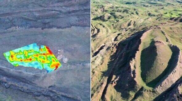
Archaeologists have made a significant discovery in Turkey that may be linked to the biblical Noah’s Ark. Utilizing advanced Ground Penetrating Radar (GPR) technology, a research team has identified what they believe are the remains of the ancient vessel in the Durupinar Formation, located approximately 29 kilometers south of Mount Ararat.
The analysis uncovered a “chemical imprint,” along with “pieces of wood in the ground” and evidence of a structured shape resembling a large hall. This location is renowned in biblical lore as the resting place of Noah’s Ark, which, according to scripture, preserved humanity and animal species from a catastrophic flood over 4,300 years ago.
Ground-Penetrating Radar Reveals Intriguing Findings
The American team, led by independent researcher Andrew Jones from Noah’s Ark Scans, employed GPR to detect a corridor approximately 4 meters wide cutting through the formation’s core. Additionally, the scans indicated the presence of central and side walkways that align with the biblical description of the ark’s interior. Research published by Express UK highlights that the GPR findings suggest the existence of three distinct layers beneath the surface, echoing the biblical account that Noah’s Ark contained three decks, as stated in Genesis 6:16.
In an interview with CBN News, Jones expressed cautious optimism about the findings. He noted, “We’re not expecting something that’s fully preserved. What’s left is the chemical imprint, pieces of wood in the ground, and the shape of a hall.” This acknowledgment underscores the challenges faced in confirming the site’s significance.
Historical Context and Ongoing Research
The Durupinar Formation has intrigued researchers since it was first documented in the early 20th century. In May 1948, heavy rains and earthquakes revealed the formation, previously hidden under layers of mud, leading to its discovery by a local Kurdish herder. The site is situated near a peak that bears a notable resemblance to the ark’s described dimensions: approximately 155 meters long, 26 meters wide, and 16 meters high.
Supporters of the theory that this formation represents Noah’s Ark argue against scholars who view it as a mere natural rock structure. Jones and his team are committed to uncovering more evidence that could support the latter position. The GPR scans have revealed angular structures extending as deep as 6 meters below the surface, which could indicate compartments consistent with a man-made vessel.
Jones emphasized, “This is not what you’d expect to see if the site were simply a solid block of rock or the result of random mudflow debris.” He added that the findings are consistent with what one would anticipate from a vessel constructed according to biblical specifications.
The research team has also performed soil analysis, revealing distinct differences in the grass color within the formation compared to surrounding areas. William Crabtree, a fellow researcher, reported that organic matter levels within the formation were found to be double that of the surrounding soil. Crabtree explained, “If this was a wooden boat and the wood had rotted over time, we would expect to see elevated levels of potassium, changes in pH, and higher organic content—and that’s exactly what we’re finding.”
Future plans include expanding soil testing beyond the 22 samples already collected and conducting core drilling to gather more data. Jones stated, “We want to compare what’s inside the formation to what’s outside. That could give us a much clearer picture of whether this is truly something man-made.”
As the team continues its efforts, the implications of their findings could reshape our understanding of one of history’s most enduring legends.